A re-assessment of tower height and sampling heights at the Amazon Tall Tower Observatory
Carlos A. Sierra, 8 Feb 2025
I recently noticed a number of inconsistencies in the reports of sampling-inlet heights as well as the total height of the tall tower at the Amazon Tall Tower Observatory (ATTO). It is commonly reported that the total height of the tower is 325 m above the ground level (agl). This is the value reported in the article of Andreae et al. 2015, the ATTO website, and Wikipedia. In previous research of our group, we have also reported that the inlet height for greenhouse gas (GHG) measurements is 321 m agl such as in this article. However, this sampling height is inconsistent with markings placed on the tower that indicate a height of 321 m agl at the base of the platform on the top level of the tower. The sampling inlets are located 3 m above the 321 m mark on the tower, so if these markings are correct, the sampling inlets are located at 324 m agl and not at 321 m agl as we previously thought. Furthermore, one clearly sees that the top of the tower is a few meters above the inlets for GHGs, which implies that the total height of the tower is not 325 m agl as commonly reported, but instead at least 6 to 7 m higher than this.
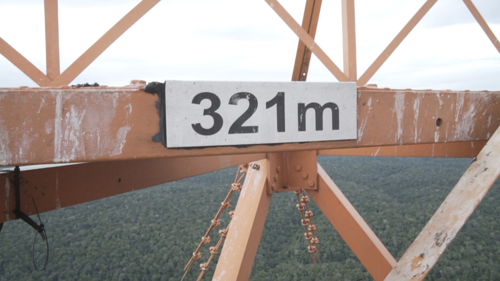 Mark on the tower indicating the 321 m height. This mark is at the base of the platform at the top of the tower.
This inconsistency is problematic for two reasons; first, for a large research scientific infrastructure such as ATTO it is very important to hold strong standards of technical accuracy, which are foundations for scientific credibility. Second, ATTO is commonly reported as the tallest infrastructure of the South American continent, and it is frequently compared to other structures built in different countries in the region and the rest of the world. Because it is a record-setting structure, it is important that there are no ambiguities in reporting its height for comparison purposes, and to avoid disputes about the relative ranking of ATTO with respect to other tall structures.
 Top of the tower, with picture taken from the upper-most platform. The tip of the tower is the mast at the center. I performed measurements with a laser meter until the point where three horizontal bars intersect the mast.
Source of previous estimates
The sampling inlets for GHG were originally installed by Uwe Schultz from the Max Planck Institute for Biogeochemistry. I asked him personally about the source of the quoted inlet height of 321 m agl, and he told me that at the time of installation there were no marks on the tower, they only knew about the heights of the main platforms, and recorded 321 m height in their notes, which were later quoted in other internal documents.
When the ICOS autosampler was installed, I recorded this estimate of inlet height in the sampler’s program, and the data processing system of the sampler always reports this sampling height. The FTIR instrument was installed months later, and the tallest inlet height is also frequently quoted as 321 m agl. It is likely that the information about the inlet height was simply reproduced without further confirmation. I am responsible for not checking the inlet heights before and simply quoting the 321 m value without further checks on other technical documentation of the tower construction.
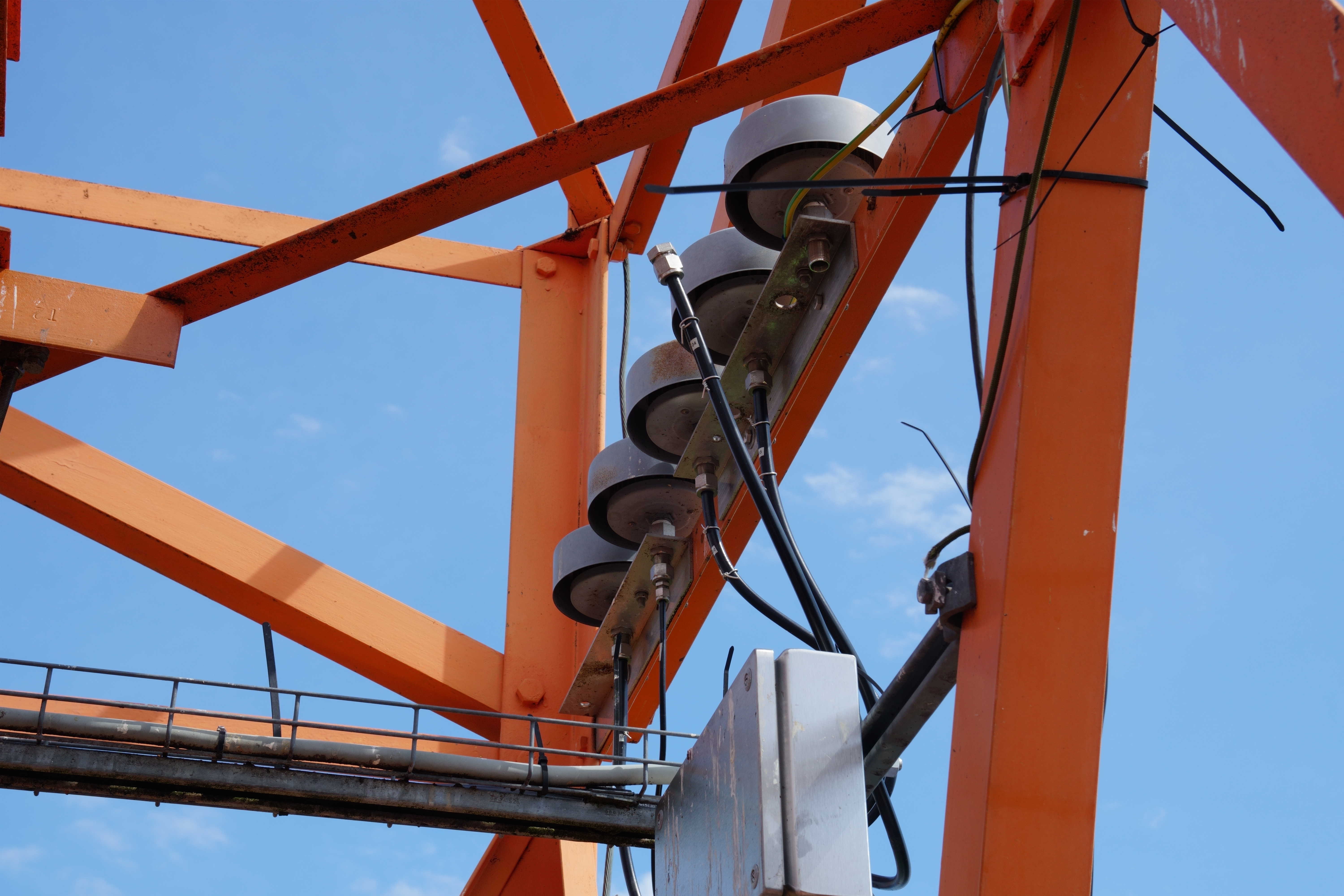 Sampling inlets for greenhouse gas measurements. They are located 3 m above the 321 m mark.
Testing the marks on the tower
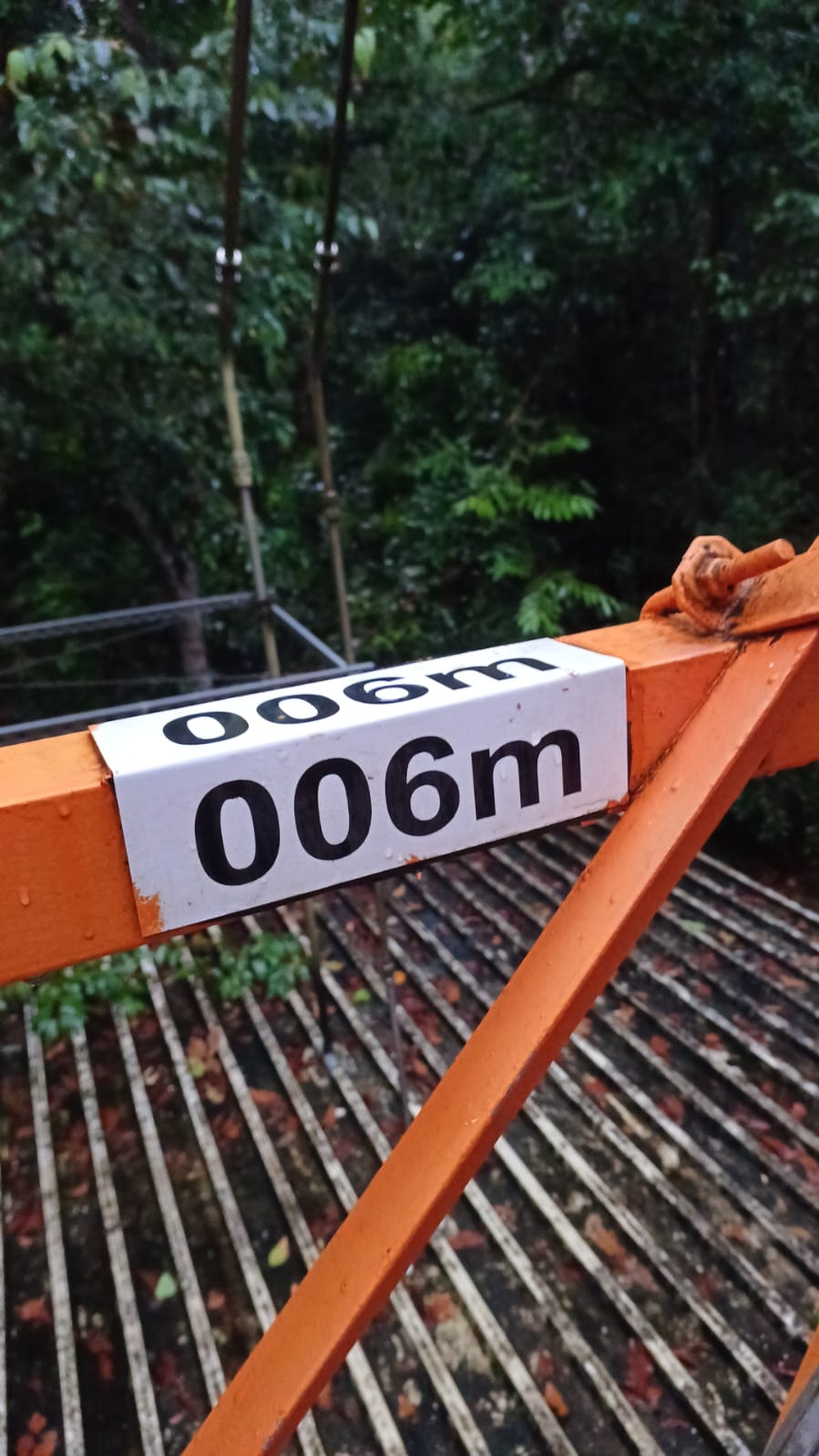
If the original estimate of 321 m is uncertain, it is therefore important to test whether the marks on the tower are correct. I used a laser meter (Nikon Forestry Pro II) that has a precision of 0.1 m to corroborate the height marks on the tower. The first mark on the tower is at 6 m agl. I obtained the following readings from the laser meter: 6.1, 5.9, 6.1, and 5.8 m, which correspond to an average of 6.0 ± 0.1 m, in agreement to the reported mark in the tower.
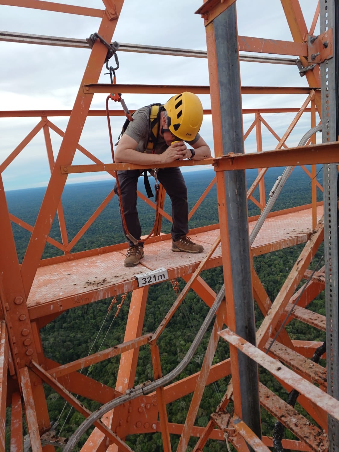 Testing the laser meter from the top platform at 321 m agl. Foto courtesy of Sipko Bulthuis.
The second mark on the tower indicates 12 m. Three measurements with the laser meter gave values of 11.5, 12.0 and 11.9 m, which is equivalent to an average of 11.8 ± 0.3 m. These measurements are also consistent with the marks on the tower.
 Six meter mark tested with the laser meter. Foto courtesy of Sipko Bulthuis.
The last measurements were done on the top of the tower, at the base of the last platform where the mark of 321 m is located. The measurements with the laser meter were 320.7, 320.7, 320.9, and 321.5 m, which give an average of 321.0 ± 0.4 m. Again, the measurements with the laser meter are consistent with the marks on the tower and confirm that these are correct.
New estimates of inlet height and total tower height
These measurements with the laser meter confirm that the height of the sampling inlets for GHG measurements is 324 agl, 3 m above the previously reported height.
Furthermore, these measurements lead to the conclusion that the total height of ATTO tower is not 325 m. From the top platform, I made measurements of the distance between my eye and the tip of the tower, to a point where three horizontal bars intersect (see picture above), about one meter below the actual tip. These measurements gave an average of 7.5 ± 0.2 m, at an inclination angle of 75.1 ± 0.4 degrees. I had to do these measurements to obtain the total distance from the 321 m mark and the tip because the laser meter didn’t provide accurate measurements using the two-point function for heights. This is a known issue with the instrument when one of the points is too close to the observer (< 7 m), which was the case at the top platform of the tower. Using the Pythagorean trigonometric identity, and adding the distance from my eye to the base of the platform, I estimated a distance from the 321 m mark and the top intersection of the tower of 8.9 ± 0.2 m, and therefore the estimated total height of the tower until this point was 329.9 ± 0.2 m.
These measurements imply that the height of the ATTO tower is not 325 m as previously reported, but in a range between 330 and 331 m agl. I later obtained a design map of the tower structure from Jürgen Kesselmeier, confirming that the height of the total structure, including the lighting rod, is 331 m agl. The commonly quoted height of 325 m agl corresponds to the structure without the lighting rod, and it’s the height used for all engineering designs. But as a man-made structure, the total height of the tower is 331 m agl.
 Heights above ground level (agl) at the top of the ATTO tower. The total height of the tower is 331 m agl, the total height without the lighting rod is 325 m, and the inlets from GHG measurements are located at 324 m agl.
The ground level uncertainty
The 331 m height pertains only to the structure of the tower, from its base to the tip, but it is not necessarily the distance from the ground level. This is because the tower in supported by a concrete base on top of the forest floor. This base, on one of the sides, is 0.35 m tall, and 0.13 m tall on the shallowest side. This implies that if one wants to be rigorous in reporting the height of the tower with respect to the ground level, a value of about 0.24 m should be added. However, this a relatively small correction, and within the uncertainty range of the measurements with the laser meter I performed.
Given that the terrain on the plateau where the tower is located is not uniformly flat, this above ground level uncertainty could be easily ignored. Therefore, reporting the total height of the tower as 331 m agl seems to be reasonable, as well as the height of the inlets for GHG as 324 m agl.
 Zero meter mark that defines the reference level for tower heights. It is possible to see the this reference level is above a concrete platform, which in turn is 0.13 - 0.35 m above the forest floor. Foto courtesy of Sipko Bulthuis.